Bundle up! The coldest air so far this season has arrived. Today will be mostly sunny with highs only reaching the low to mid 20s. That’s more than 20 degrees below average for this time of year. Fortunately there will not be much wind so wind chill won’t be a factor today.
Temps will drop into the low teens tonight. Tomorrow will be mostly cloudy and breezy with highs in the low 30s. There is a slight chance of light rain or snow late Saturday into Saturday night. Otherwise, the weekend will be dry and a bit warmer. Highs will reach the mid 40s on Saturday, upper 30s Sunday.
Our big warm-up comes next week. There will be plenty of sunshine with high temps in the low to mid 50s on Monday, Tuesday and Wednesday.
Blog
A Variety of Weather This Weekend
This weekend’s weather will bring a little something for everyone. Rain, snow, sunshine with highs in the 50s… It’s all possible in different places at different times throughout the weekend.
Two weather systems will impact our region this weekend, bringing a chance of rain and snow. The first system has already developed and will bring snow to northeastern South Dakota, North Dakota and much of Minnesota through tonight. A Winter Weather Advisory is in effect this afternoon and tonight for parts of northeastern South Dakota, western Minnesota and eastern North Dakota. 2 to 4 inches of snow is possible in areas along and north of US Highway 212 through tonight.
Between systems the weather will actually be quite nice, especially in Sioux Falls and across the southern portions of our KSFY coverage area. The sun will make an appearance and highs will warm into the low 50s Saturday afternoon.
The second system, a cold front, will blast through Saturday night into Sunday morning. The front will bring scattered rain showers to Sioux Falls and much of eastern and southeastern South Dakota, southwestern Minnesota and northwestern Iowa. a few places could see if you scattered light snow showers as temperatures dropped to near freezing on Sunday morning.
Next week will be cooler than average with highs only reaching the mid to upper 30s on Monday and Tuesday. Yet another system could bring a quick shot of snow late Monday into Tuesday.
Cloudy Today, Rain and Snow by the Weekend
November is here and it is definitely going to feel like it for the next week or so. Today will be mostly cloudy with high temps ranging from the upper 30s in the north to the mid to upper 40s in Sioux Falls and across the south. There won’t be much wind, so today will probably feel at least a little warmer than it has the past couple of days.
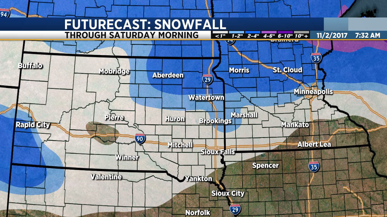
We are keeping a very close eye on a system that will bring rain and snow to parts of our region Friday into Saturday. Forecast models continue to suggest that the heaviest snow will fall across northeastern South Dakota from about midday Friday through Friday night, ending sometime Saturday morning. Locations along and north of US Highway 212 could get 2 to 3 inches of snow with locally heavier amounts. This includes Watertown, Redfield, Aberdeen, Webster and Sisseton along with the Highway 212/Highway 12 corridor across Minnesota to the Twin Cities.
South of Highway 212 snowfall amounts will be lighter. It will also be a bit warmer which means there will be some rain and freezing rain that mixes with the snow. Sioux Falls and locations along I-90 could get light rain and snow on Friday into Friday night but amounts will be light.
A second system will roll through on Sunday bringing another brief round of light rain and snow Sunday morning. Another system will bring a chance of rain and snow showers late Monday into Tuesday. Temperatures will stay below average through the middle of next week.
Both ShawnCable.com and WXLab.com are the personal websites of Shawn Cable. Shawn is a freelance meteorologist based in Sioux Falls, South Dakota.