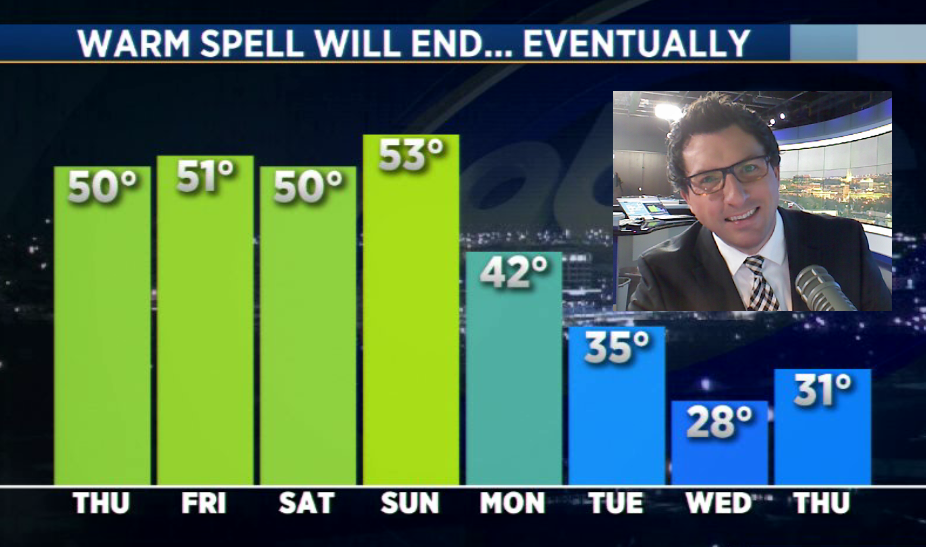
I hope you had a chance to enjoy the mild temperatures over the past several days, because we are going to make a very quick transition to winter today.
A Blizzard Warning is in effect for much of northeastern South Dakota today and includes Aberdeen, Watertown, Redfield and Sisseton. A Winter Weather Advisory is in effect for a large part of central, southern and western South Dakota and southwestern Minnesota and includes Sioux Falls, Pierre, Rapid City, Mitchell, Huron, Mobridge, Winner, Pipestone and Marshall.
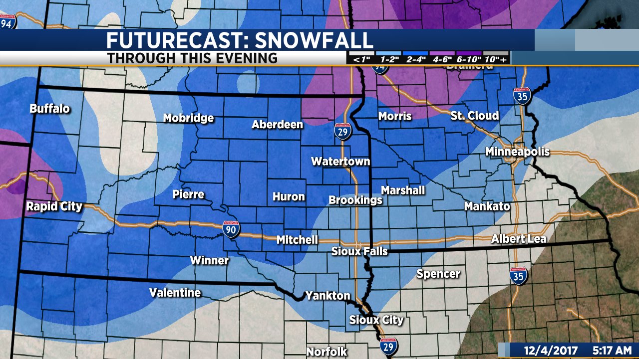
Mild temperatures in the 30s and 40s this morning will fall quickly today as a powerful cold front blast across the Dakotas. Light rain will develop early in some places, changing to snow as temperatures fall. Snow will continue through the afternoon with the heaviest amounts – 3 to 5 inches – falling across northeastern South Dakota. Northwesterly wind gusts to 50+ mph will create blowing snow and blizzard conditions, especially across northeastern South Dakota and west central Minnesota where the heaviest snow will fall.
Further south and west, snowfall amounts will not be as high, but wind will still create areas of blowing snow that will reduce visibility at times.
In Sioux Falls, light rain will develop by mid to late morning and then change to snow as temperatures drop this afternoon. About an inch or two of snow is possible in the Sioux Falls area with strong wind gusts to 45 mph creating areas of blowing snow, especially in rural areas. The heaviest snow will fall across the northwest part of the Sioux Falls metro area (closer to 2 inches) with lighter amounts the further southeast you go.
As I mentioned earlier, temperatures will drop significantly through the day. It will be mild when you leave this house this morning, but temperatures will drop into the upper 20s to low 30s by late afternoon with the wind chill factor dropping into the teens to single digits.
The snow will end from west to east late this afternoon into this evening. Tonight and tomorrow will be windy and considerably colder. High temps will only reach the mid 20s tomorrow afternoon and it looks like that’s where our temperatures will stay through most of the week.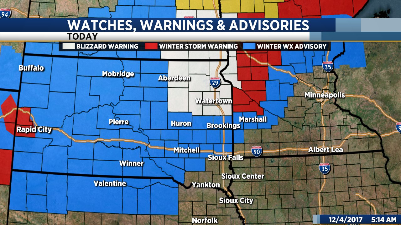
Blog
A Few More Warm Days
Today will be sunny, mild and not as windy as yesterday. High temps will range from the upper 40s to low 50s this afternoon with wind from the west at only 5 to 15 mph.
Mild temperatures will stick around through the weekend. There will be plenty of sunshine with afternoon temperatures the 50s on Friday, Saturday and Sunday.
Enjoy the above average weather while you can because this is only going to last for a few more days. Our weather pattern will change early next week and temperatures will drop considerably. By next Tuesday and Wednesday highs will only reach the 30s with even colder air rolling in by late next week.
A Sunny, Warm Thanksgiving Weekend
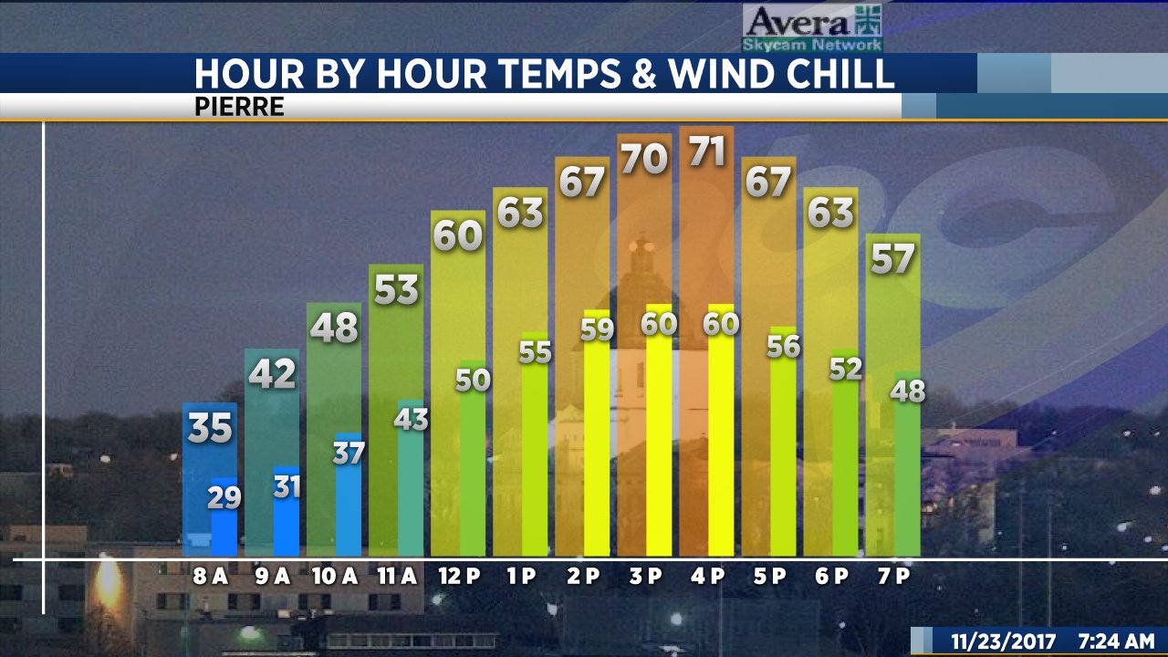
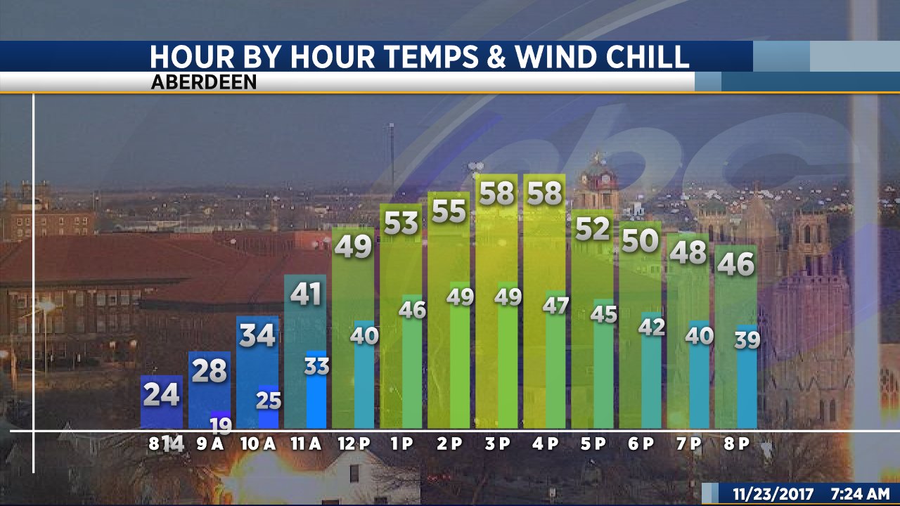
If you are traveling this holiday weekend you have absolutely nothing to worry about… When it comes to the weather, at least. The entire weekend will be absolutely amazing… Mostly sunny with high temperatures that are well above average for this time of year.
Today will be sunny and warm with highs ranging from the mid 50s in Sioux Falls to the low 70s across central and western South Dakota. Tomorrow will be mostly sunny and warmer but breezy. High temps will be in the mid to upper 50s across the entire region tomorrow afternoon.
A front will drop our high into the upper 40s Saturday, but we’ll will bounce back into the mid 50s on Sunday. High temps will reach the 60s on Monday.
As of right now it looks like Monday will be the last day of our unseasonably warm weather. A front will bring highs back to the low 40s by Tuesday with cooler temps hanging around through most of next week.

Both ShawnCable.com and WXLab.com are the personal websites of Shawn Cable. Shawn is a freelance meteorologist based in Sioux Falls, South Dakota.