Mild Today… Snowy, Much Colder Weather on the Way

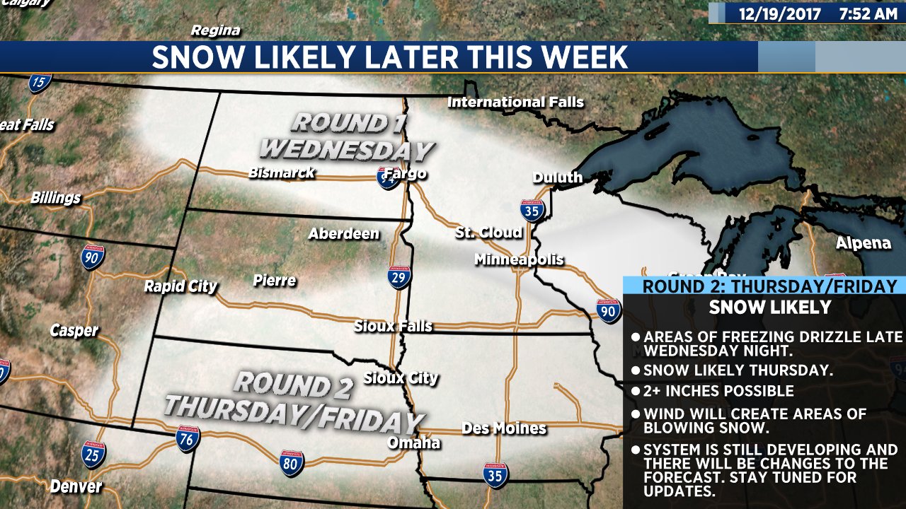
Our main focus continues to be the potential for snow later this week. Our latest forecast models have cut the moisture a bit, however, snow is still likely Wednesday night and Thursday into Friday. More on the possibility of winter weather in a moment…

We still have a couple of nice, mild days to look forward to. Today will be mostly sunny with high temps ranging from the 40s in Sioux Falls and across central South Dakota to the upper 30s in the north. Wind will be fairly light. Tomorrow will be slightly cooler and a bit breezy but still well above average for this time of year.

Our overall weather pattern will change significantly Wednesday night into Thursday. A powerful system will bring a brief shot of rain and freezing drizzle Wednesday night. That will quickly change to snow and continue Thursday into Friday morning. As of right now, I think the area of most significant impact will be southeastern South Dakota, southern Minnesota and northwestern Iowa. Snowfall amounts will be lighter across central and northern South Dakota. It’s too early to get specific with snowfall amounts, but there will likely be some accumulation… At least a couple of inches, possibly more in some places. In addition to the snow, wind will create areas of blowing snow at times on Thursday into Thursday night.

Behind the system, bitterly cold arctic air will pour into our region. By Christmas Day, lows will drop into the single digits either side of zero with highs ranging from the single digits in Sioux Falls and Aberdeen to the teens across central South Dakota.

Snow later this week


Warm Today, Snow Possible Later This Week

We have a couple more sunny, warm days on the way. We are also keeping an eye on a potential winter storm that could impact the region later this week.

Today will be sunny and warm. High temps will range from the upper 40s in Sioux Falls to the low to mid 50s across central South Dakota. That’s 20 or more degrees above average for this time of year. Tomorrow and Wednesday won’t be quite as warm, but it will be dry with highs in the 40s.

We might have a white Christmas after all. There will be a big change in our weather pattern later this week. A winter storm system could bring snow and blowing snow to our region by Thursday and Friday. It’s way too early to get specific, but as of right now our data is suggesting that this could be a snowfall worthy of snowblowers and snowplows.

In addition to snow, it is going to get colder. A lot colder. By next weekend, lows are going to drop into the lower single digits with highs only reaching the teens by Saturday and Christmas Eve. So, whether we are shoveling snow or not, it looks like we will definitely need our warm winter coats by Christmas.

A Mostly Cloudy, Mild Weekend

The weekend ahead will be mostly cloudy, but it will also be mild and not very windy. High temperatures will reach the 40s each day, which is between 10 and 20 degrees above average for this time of year. Parts of central and western South Dakota could warm into the low 50s today with cooler 40s tomorrow and Sunday.  
This weather pattern will hold strong into next week. Monday, Tuesday and Wednesday will be partly cloudy to mostly sunny with highs in the low to mid 40s.

Our weather will change dramatically on Thursday as a strong cold front blasts across the region. Wind, snow and much colder temperatures are possible by Thursday into Friday of next week. While it’s way too early to get specific with numbers, at this point I don’t think snow amounts will be huge. This does, however, give a little hope for at least some white on Christmas. I’ll let you know how things develop.