Cloudy Today, Rain and Snow by the Weekend

November is here and it is definitely going to feel like it for the next week or so. Today will be mostly cloudy with high temps ranging from the upper 30s in the north to the mid to upper 40s in Sioux Falls and across the south. There won’t be much wind, so today will probably feel at least a little warmer than it has the past couple of days.

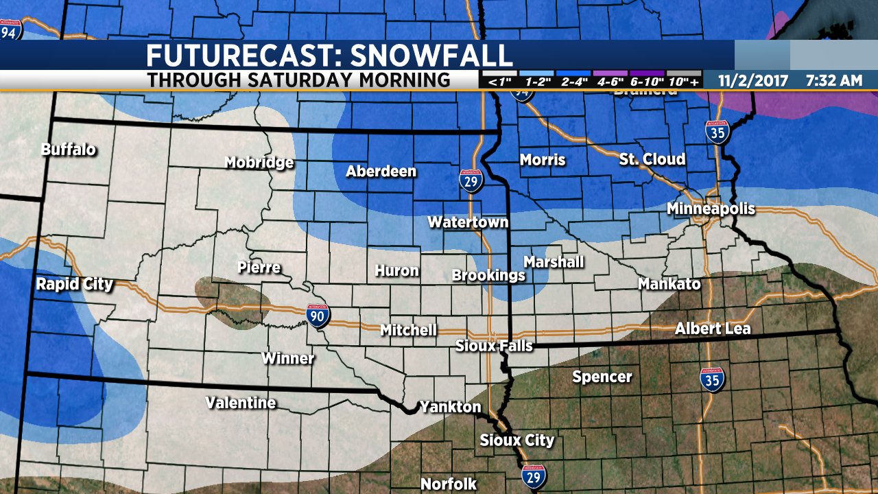
We are keeping a very close eye on a system that will bring rain and snow to parts of our region Friday into Saturday. Forecast models continue to suggest that the heaviest snow will fall across northeastern South Dakota from about midday Friday through Friday night, ending sometime Saturday morning. Locations along and north of US Highway 212 could get 2 to 3 inches of snow with locally heavier amounts. This includes Watertown, Redfield, Aberdeen, Webster and Sisseton along with the Highway 212/Highway 12 corridor across Minnesota to the Twin Cities.

South of Highway 212 snowfall amounts will be lighter. It will also be a bit warmer which means there will be some rain and freezing rain that mixes with the snow. Sioux Falls and locations along I-90 could get light rain and snow on Friday into Friday night but amounts will be light.

A second system will roll through on Sunday bringing another brief round of light rain and snow Sunday morning. Another system will bring a chance of rain and snow showers late Monday into Tuesday. Temperatures will stay below average through the middle of next week.

Flash Flood Warning United StatesNational Weather Alerts

Flash Flood Warning
...flash Flood Warning Remains In Effect Until 3 Am Ast Early This Morning For Saint John And Saint Thomas... At 109 Am Ast, Doppler Radar Indicated Thunderstorms Producing Heavy Rain Across The Warned Area. Between 1 And 4 Inches Of Rain Have Fallen. Additional Rainfall Amounts Of 1 To 3 Inches Are Possible In The Warned Area. Flash Flooding Is Ongoing Or Expected To Begin ...Read More.
Effective: October 4, 2023 at 1:09amExpires: October 4, 2023 at 3:00amTarget Area: Saint John; Saint Thomas

Flash Flood Warning
...flash Flood Warning Remains In Effect Until 3 Am Ast Early This Morning For Saint Croix... At 108 Am Ast, Doppler Radar Indicated Thunderstorms Producing Heavy Rain Across The Warned Area. Between 1 And 3 Inches Of Rain Have Fallen. Additional Rainfall Amounts Of 1 To 3 Inches Are Possible In The Warned Area. Flash Flooding Is Ongoing Or Expected To Begin ...Read More.
Effective: October 4, 2023 at 1:08amExpires: October 4, 2023 at 3:00amTarget Area: Saint Croix

Flood Warning
...the Flood Warning Continues For The Following Rivers In Florida... St Johns River Near Astor Affecting Lake And Volusia Counties. .recent Heavy Rainfall Over And Upstream From Astor Combined With Northeast Winds Have Brought The Saint Johns River At Astor Into Moderate Flood. River Levels Are Forecast To Remain In Moderate Flood Between 3.0 And 3.1 Feet Through The Weekend. ...Read More.
Effective: October 3, 2023 at 9:22pmExpires: October 4, 2023 at 11:00amTarget Area: Lake; Volusia

Flood Warning
...the Flood Warning Continues For The Following Rivers In Florida... Peace River At Arcadia At Sr 70 Affecting Desoto County. For The Peace...including Bartow, Zolfo Springs At Sr 17, Arcadia At Sr 70...minor Flooding Is Forecast. ...flood Warning Remains In Effect Until Early Friday Morning... * What...minor Flooding Is Occurring And Minor Flooding Is Forecast. ...Read More.
Effective: October 3, 2023 at 8:33pmExpires: October 6, 2023 at 2:00amTarget Area: DeSoto

Flood Warning
...the Flood Warning Continues For The Following Rivers In Florida... Fisheating Creek Near Palmdale Affecting Glades County. For The Fisheating Creek...including Palmdale...minor Flooding Is Forecast. ...flood Warning Remains In Effect Until Further Notice... * What...minor Flooding Is Occurring And Minor Flooding Is Forecast. ...Read More.
Effective: October 3, 2023 at 12:05pmExpires: October 4, 2023 at 12:15pmTarget Area: Glades

Flood Warning
...flood Warning In Effect Until 145 Am Cdt Wednesday... * What...small Stream Flooding Caused By Excessive Rainfall Is Occurring. * Where...a Portion Of Western Texas, Including The Following County, Scurry. * When...until 145 Am Cdt. ...Read More.
Effective: October 3, 2023 at 10:36pmExpires: October 4, 2023 at 1:45amTarget Area: Scurry

Freeze Warning
...freeze Warning In Effect From 3 Am To 9 Am Mdt Wednesday... ...freeze Watch In Effect From Late Wednesday Night Through Thursday Morning... * What...for The Freeze Warning, Sub-freezing Temperatures As Low As 31 Expected. For The Freeze Watch, Sub-freezing Temperatures As Low As 29 Possible. ...Read More.
Effective: October 3, 2023 at 6:30pmExpires: October 4, 2023 at 9:00amTarget Area: Alamosa Vicinity, Central San Luis Valley Below 8500 Ft; Del Norte Vicinity, Northern San Luis Valley Below 8500 Ft; Southern San Luis Valley

Freeze Warning
...freeze Warning Remains In Effect From 3 Am To 8 Am Mdt Wednesday... * What...sub-freezing Temperatures As Low As 29 Expected. * Where...upper Rio Grande Valley. * When...from 3 Am To 8 Am Mdt Wednesday. * Impacts...frost And Freeze Conditions Could Kill Crops, Other ...Read More.
Effective: October 3, 2023 at 9:45pmExpires: October 4, 2023 at 8:00amTarget Area: Upper Rio Grande Valley

Freeze Warning
...freeze Warning In Effect From 3 Am To 9 Am Mdt Wednesday... * What...sub-freezing Temperatures As Low As 28 Degrees Expected. * Where...sanpete Valley And Southwest Utah. * When...from 3 Am To 9 Am Mdt Wednesday. * Impacts...frost And Freeze Conditions Will Kill Crops, Other Sensitive Vegetation And Possibly Damage Unprotected Outdoor ...Read More.
Effective: October 3, 2023 at 3:09pmExpires: October 4, 2023 at 9:00amTarget Area: Sanpete Valley; Southwest Utah