November is here and it is definitely going to feel like it for the next week or so. Today will be mostly cloudy with high temps ranging from the upper 30s in the north to the mid to upper 40s in Sioux Falls and across the south. There won’t be much wind, so today will probably feel at least a little warmer than it has the past couple of days.
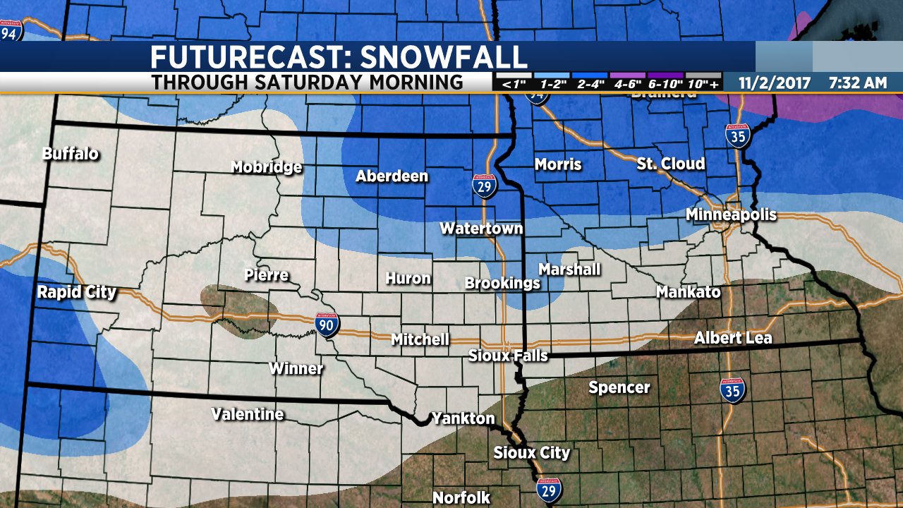
We are keeping a very close eye on a system that will bring rain and snow to parts of our region Friday into Saturday. Forecast models continue to suggest that the heaviest snow will fall across northeastern South Dakota from about midday Friday through Friday night, ending sometime Saturday morning. Locations along and north of US Highway 212 could get 2 to 3 inches of snow with locally heavier amounts. This includes Watertown, Redfield, Aberdeen, Webster and Sisseton along with the Highway 212/Highway 12 corridor across Minnesota to the Twin Cities.
South of Highway 212 snowfall amounts will be lighter. It will also be a bit warmer which means there will be some rain and freezing rain that mixes with the snow. Sioux Falls and locations along I-90 could get light rain and snow on Friday into Friday night but amounts will be light.
A second system will roll through on Sunday bringing another brief round of light rain and snow Sunday morning. Another system will bring a chance of rain and snow showers late Monday into Tuesday. Temperatures will stay below average through the middle of next week.

Still Cold, Not As Windy Today
Today will be just as cold as yesterday, but fortunately not as windy. High temperatures will only reach the upper 30s this afternoon with the wind from the west, switching to the south at only 5 to 15 mph.
Bundle up the kiddos tonight. Trick-or-treat time temperatures will start in the mid to upper 30s late this afternoon and fall into the low 30s by mid evening. It is going to get breezy tonight, but I think it will hold off until most of our little trick-or-treaters are home with their bags of candy. The wind will be from the south at 5 to 15 mph through mid evening, but it will become gusty by around or shortly after 10 PM.
A few scattered snow showers are possible first thing tomorrow morning. Tomorrow will be mostly cloudy and breezy with high temps in the low 50s.
High temps will stay in the 40s through most of the week with a chance of rain and snow late Friday into early Saturday morning. The weekend will be mostly cloudy with a sprinkle or two possible (that sprinkle could come in the form of a rain or snow shower depending on where and when.) It will get warmer this weekend with highs in the mid to upper 40s Saturday, mid 50s on Sunday.
Another Cold, Windy Day
We are only a couple days away from November and it definitely feels like it. Today will be mostly cloudy, windy and cold with a sprinkle or two possible this afternoon. High temps will only reach the upper 30s this afternoon with northwesterly wind gusts to between 30 and 40 mph.
Halloween will be just as cold, but fortunately not nearly as windy. Once again, highs will only reach the upper 30s tomorrow afternoon. You’ll have to bundle up the kiddos for trick-or-treating. Temperatures will drop into the low 30s by tomorrow evening.
Temperatures will bounce from the 40s to 50s later this week with a slight chance of rain or snow on Wednesday and again on Friday. The weekend is actually lookin’ pretty good with a mix of clouds and sunshine, a slight chance of a shower, and high temps in the 50s.
Sunny and Warm Today, Big Changes Ahead
This is it… Today is the day! The warmest, least windy day we’re going to have for quite some time. If you’re hoping to get in a round of golf, need to get some yard work taken care of, or simply want to sit on the porch and enjoy the sunshine, you might want to knock off work a little early today and make up for it on Thursday and Friday. You won’t want to be doing stuff outside on Thursday and Friday anyhow.
Today will be sunny with high temps ranging from the upper 60s in Sioux Falls to the mid 70s across central and western South Dakota. Wind will be fairly light from the northwest at only 5 to 15 mph.
A cold front will blast across the Dakotas late tonight and tomorrow, bringing strong wind gusts, much colder temperatures and even a little snow. The wind will kick in first thing tomorrow with gusts to 40 mph in Sioux Falls, 50 to 55 mph across central and western South Dakota. High temps will reach the low to mid 50s by about noon tomorrow with temperatures dropping into the low 40s by late tomorrow afternoon.
Light snow will develop Thursday night and continuing to Friday. Will get one-half inch or less in Sioux Falls. Parts of northeastern South Dakota and southwestern Minnesota along the Buffalo Ridge could get 1 to 2 inches of accumulation. The snow won’t be a big deal on its own, but the wind will create blowing snow late Thursday night into Friday. There could be a few issues with travel. Stay tuned for updates.
The weekend will be dry and cool with morning low temps in the lower 20s and highs in the low 40s Saturday, warming to around 50 degrees on Sunday afternoon.
Windy and Cold Today… An Awesome Day Tomorrow
It is going to be another windy day. It won’t be quite as windy as yesterday – we’re talkin’ gusts to around 40 mph throughout the day – but it will be colder. Highs will only reach the low 50s this afternoon. Central and western South Dakota will be a bit warmer with afternoon highs reaching the low 60s.
The wind will die down late this afternoon into this evening and that will lead us into an absolutely incredible day tomorrow. Wednesday is definitely the nicest day on the 7 Day Forecast with sunshine, highs in the upper 60s to low 70s and just a light northwest breeze.
A powerful cold front will blast across the region on Thursday, bringing more wind and much colder temperatures as we roll toward the weekend. By Friday morning, temps will drop into the 20s with highs only reaching the upper 30s to low 40s on Friday afternoon. The front will be mostly dry, but a few scattered light rain or snow showers will be possible late Thursday night into Friday morning. At this time I do not expect any accumulation.
While we will warm a bit through the weekend, temperatures will remain below average. High temps will stay in the low to mid 40s on Saturday, warming to near 50 on Sunday. Morning low temperatures will drop to the low to mid 20s through the weekend.
Both ShawnCable.com and WXLab.com are the personal websites of Shawn Cable. Shawn is a freelance meteorologist based in Sioux Falls, South Dakota.