It is another bitter, dangerously cold morning. Once again, a Wind Chill Advisory is in effect for most of the region through this morning. Actual temperatures are colder than 20 below zero with the wind chill factor dropping to 40 below or colder at times.
Despite the cold this morning, most places will climb back above zero this afternoon. That’s after over three straight days of below zero temperatures. If you’re keeping track, we dropped below zero at midnight on December 30th… So we’re looking at about 80 to 85 straight hours of below zero temperatures by the time we creep back above zero later today.
Unfortunately, our time above zero will be short-lived. A cold front will blast across the Dakotas later today into tonight, bringing a few scattered light snow showers later today into this evening and another below zero night tonight. While most nights this week will drop below zero, the good news is that all the high temperatures on the 7 Day forecast are above zero. By the weekend, morning lows will be back above zero with high temps in the 20s.

Snow Today… Deadly Dangerous Cold this Weekend
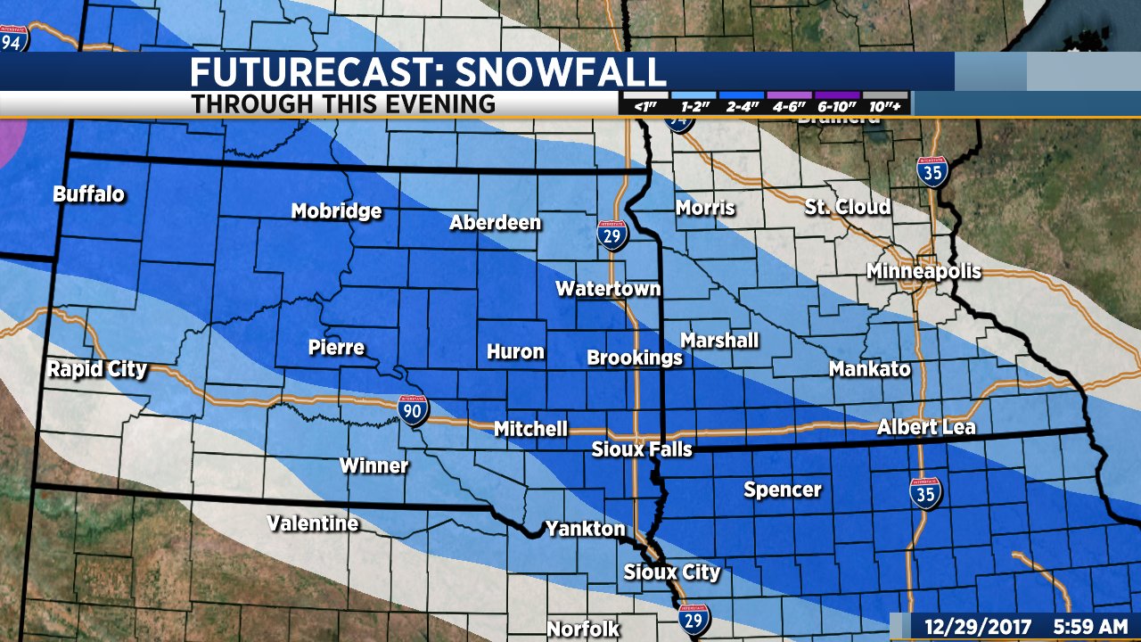
The weather is going to give us plenty of excitement as we head into the new year. 2 to 4 inches of snow today will be followed by frigid, dangerously cold temperatures this weekend. Most places will drop below zero this evening and won’t claw their way back above zero until sometime Tuesday afternoon.
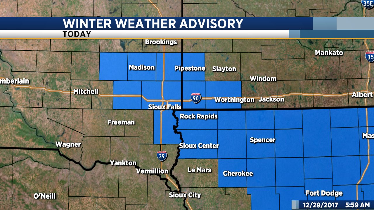
Snow will develop quickly this morning and continue into the afternoon. A Winter Weather Advisory is in effect through this afternoon for Sioux Falls and parts of southeastern South Dakota, southwestern Minnesota and northwestern Iowa. 2 to 4 inches of light, fluffy snow is possible. It won’t be terribly windy, but due to the fluffy nature of the snow even a 15 to 20 mph gust could create some visibility issues. Snow will end by late this afternoon.
After the snow, it is all about the cold. Temperatures will drop below zero this evening and stay below zero for almost four straight days. The coldest air will roll in just as we’re ringing in the new year. Sunday’s high will be close to 10 below with temperatures dropping to between 25 below and 30 below on New Year’s morning. That’s not wind chill factor, that’s the actual temperature. This is serious, deadly dangerous cold. Dress appropriately if you’re going out on New Year’s Eve.
Be safe, stay warm and have a happy New Year!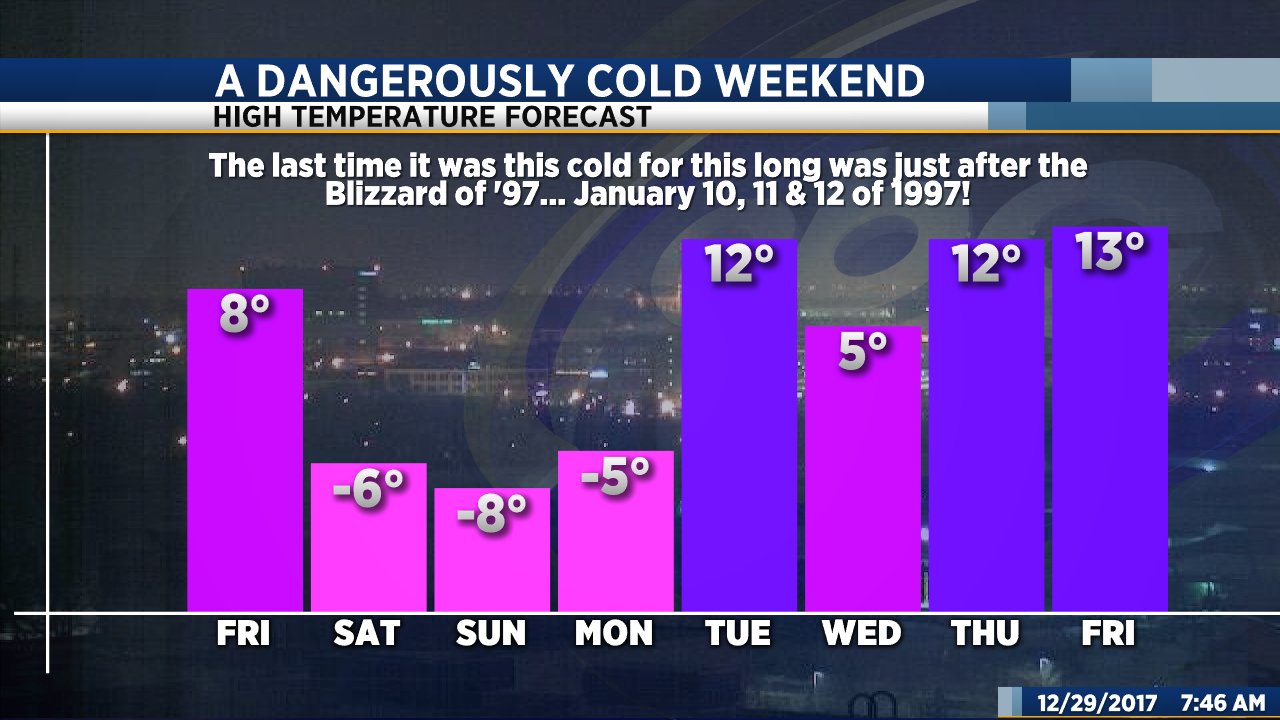
Another Frigid Day… Snow Possible Tonight
Bundle up! It is another dangerously cold morning. A Wind Chill Advisory is in effect for much of the region. The actual temperature has dropped to between 10 and 20 below with the wind chill factor dropping to 30 below or colder at times. Temperatures will gradually make their way back above zero this afternoon.
Today will be mostly sunny in the morning with clouds increasing this afternoon. Snow will develop late this afternoon and continue through tonight. An inch or two of accumulation is possible along and east of I-29 with 2 to 3 inches possible across parts of southwestern Minnesota. The snow will end by daybreak tomorrow. A second round of light snow is possible on Friday. Around an inch of accumulation is possible.
Another long lasting, even colder blast of arctic air is headed our way for the weekend. Temperatures will drop below zero Friday evening and won’t be back above zero until sometime on New Year’s Day.
Snow Tomorrow… A Very Cold Christmas
The winter weather system we have been talking about for the past couple of days will roll in late tonight and continue through Thursday and into Thursday night. The system will not be as strong as originally anticipated, but will bring a band of 1 to 3 inches of snow to the southeastern portion of our KSFY coverage area.
Areas of light freezing drizzle will develop after midnight tonight with light snow developing by or shortly after daybreak tomorrow. Snow will continue through tomorrow and into tomorrow night. Overall snow totals will range from about 1 to 2 inches with slightly higher amounts possible in some locations. Northwesterly wind gusts from 20 to 30 mph will create areas of blowing snow throughout the day tomorrow. If you are traveling, be prepared for some issues with visibility, especially in rural areas. Snow will gradually diminish from southwest to northeast tomorrow evening.
Bitterly cold arctic air will plunge southward behind this system. By the weekend, highs will only reach the teens with morning lows dropping to the single digits. Christmas Eve and Christmas Day will be bitterly cold with morning lows hovering either side of zero and highs only in the single digits to low teens.
In the meantime, we get one more day of above-average high temperature day before things change. Today will be mostly cloudy with a bit of sunshine at times this afternoon. Highs will range from the upper 30s in Sioux Falls to the low 50s across south central South Dakota. it will be a bit breezy today. Wind will be from the southeast with occasional gusts to between 20 and 30 mph.
Mild Today… Snowy, Much Colder Weather on the Way
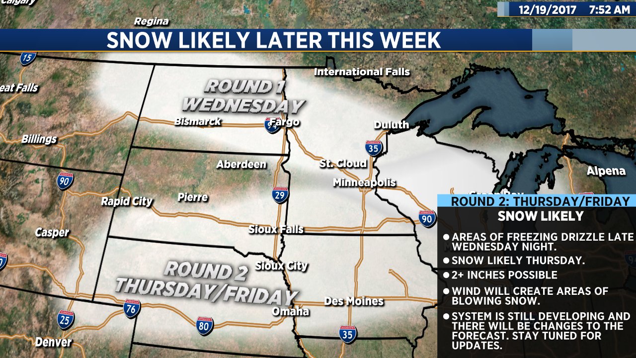
Our main focus continues to be the potential for snow later this week. Our latest forecast models have cut the moisture a bit, however, snow is still likely Wednesday night and Thursday into Friday. More on the possibility of winter weather in a moment…
We still have a couple of nice, mild days to look forward to. Today will be mostly sunny with high temps ranging from the 40s in Sioux Falls and across central South Dakota to the upper 30s in the north. Wind will be fairly light. Tomorrow will be slightly cooler and a bit breezy but still well above average for this time of year.
Our overall weather pattern will change significantly Wednesday night into Thursday. A powerful system will bring a brief shot of rain and freezing drizzle Wednesday night. That will quickly change to snow and continue Thursday into Friday morning. As of right now, I think the area of most significant impact will be southeastern South Dakota, southern Minnesota and northwestern Iowa. Snowfall amounts will be lighter across central and northern South Dakota. It’s too early to get specific with snowfall amounts, but there will likely be some accumulation… At least a couple of inches, possibly more in some places. In addition to the snow, wind will create areas of blowing snow at times on Thursday into Thursday night.
Behind the system, bitterly cold arctic air will pour into our region. By Christmas Day, lows will drop into the single digits either side of zero with highs ranging from the single digits in Sioux Falls and Aberdeen to the teens across central South Dakota.
Both ShawnCable.com and WXLab.com are the personal websites of Shawn Cable. Shawn is a freelance meteorologist based in Sioux Falls, South Dakota.