Today will be partly to mostly cloudy, breezy and warmer. High temps will range from the upper 30s in Sioux Falls to the mid 40s along the James River to the mid 50s across central and western South Dakota. Wind will be a bit gusty from the south at about 20 to 30 mph.
Mild temperatures will stick around through tomorrow, then a cold front will bring highs back to the teens by Thursday. Temps will bump back to near 30 degrees on Friday, with light snow and colder temperatures in the forecast for the weekend.

Major winter storm this weekend
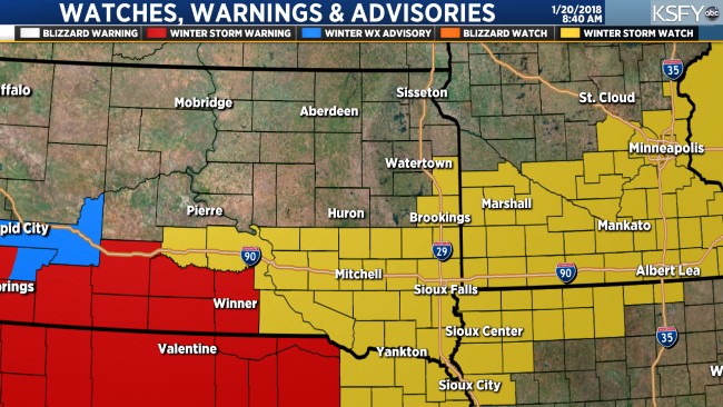
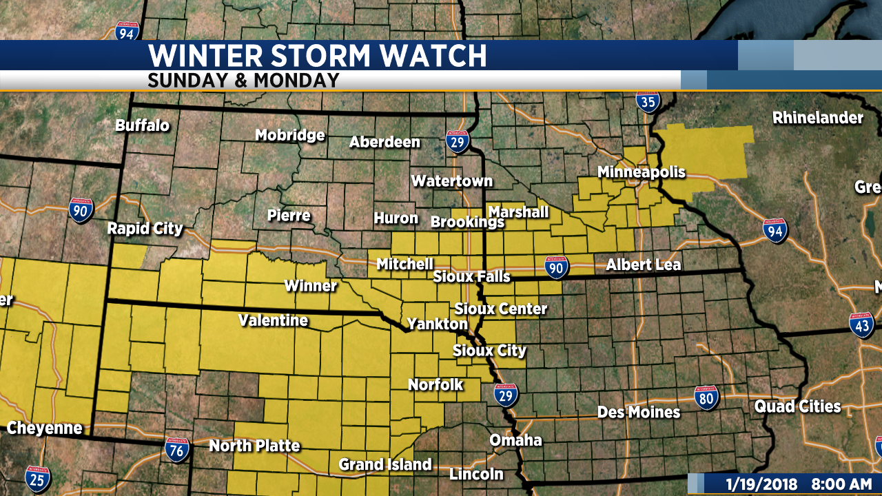
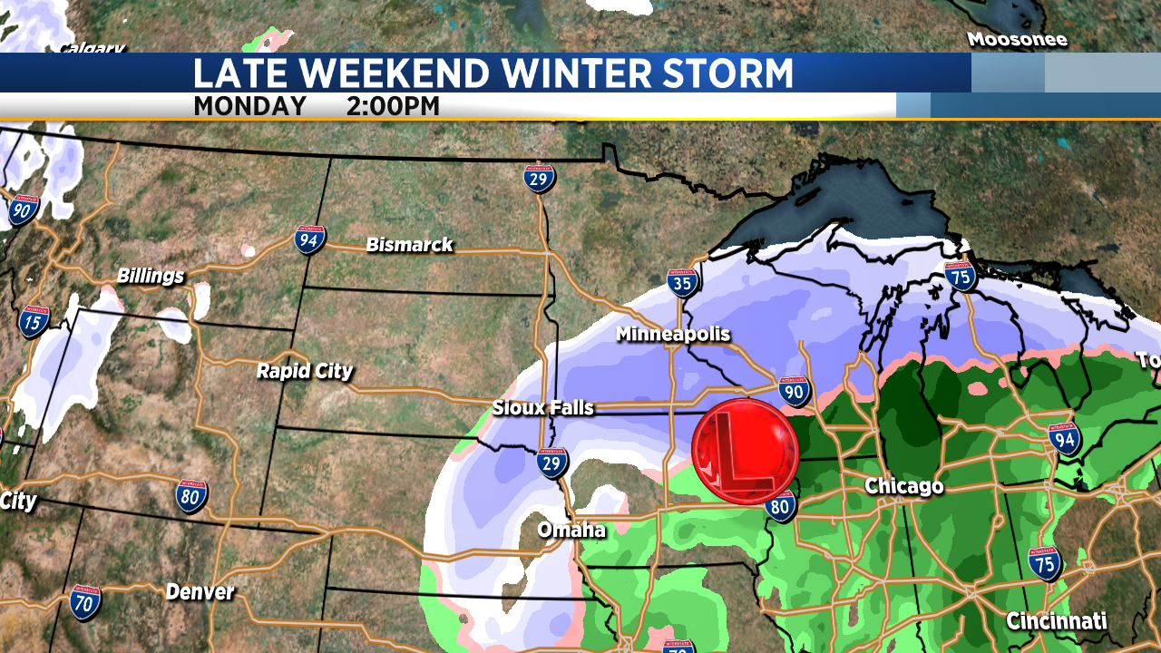
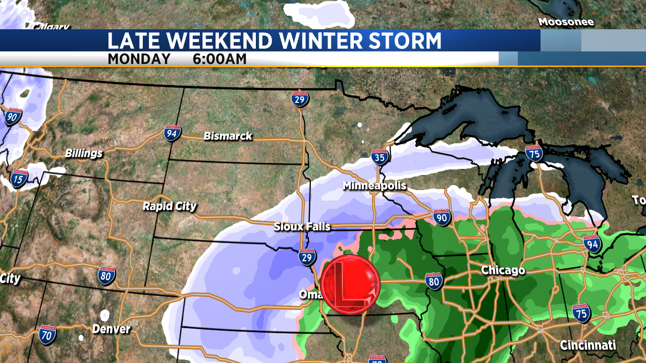
A Winter Storm Watch is still in effect from tomorrow afternoon through Monday. 6 to 10 inches of snow is possible with strong wind creating blizzard conditions at times.
Tracking a Weekend Winter Storm
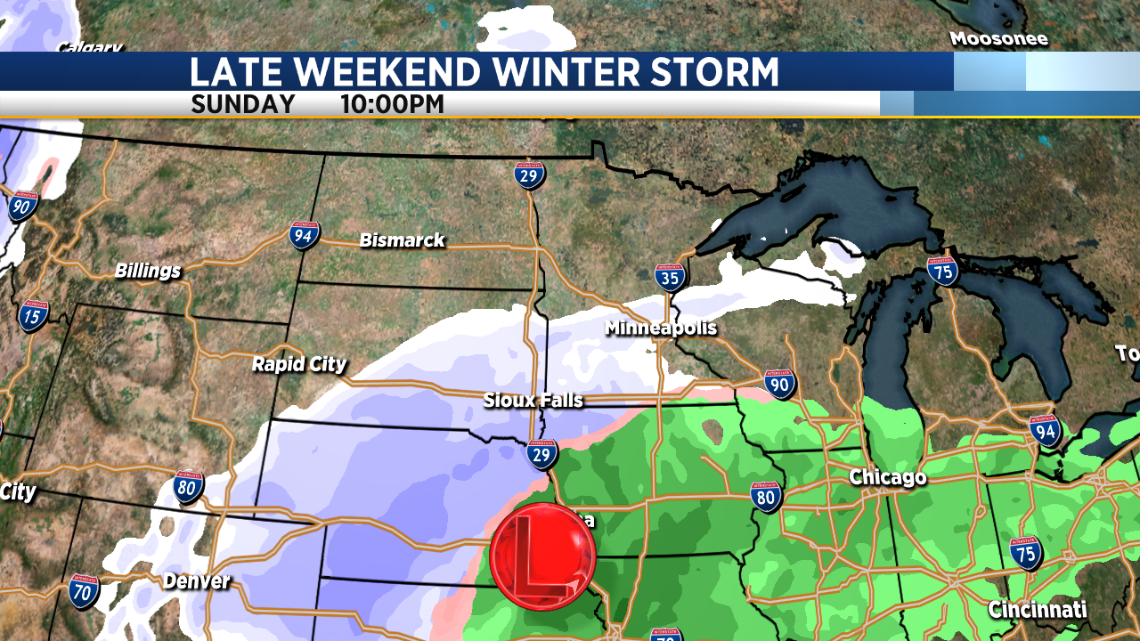
We continue to track what is looking more likely to be a fairly significant winter storm that will impact the region over the weekend. A Winter Storm Watch has now been issued by the National Weather Service and is in effect from Sunday afternoon through Monday morning.
In the meantime, we get to enjoy a couple more warm days. Today will be mostly cloudy but it will also be warmer. High temperatures will range from the upper 40s to low 50s this afternoon. Tomorrow will be a bit cooler but still mild with high temps in the low to mid 40s.
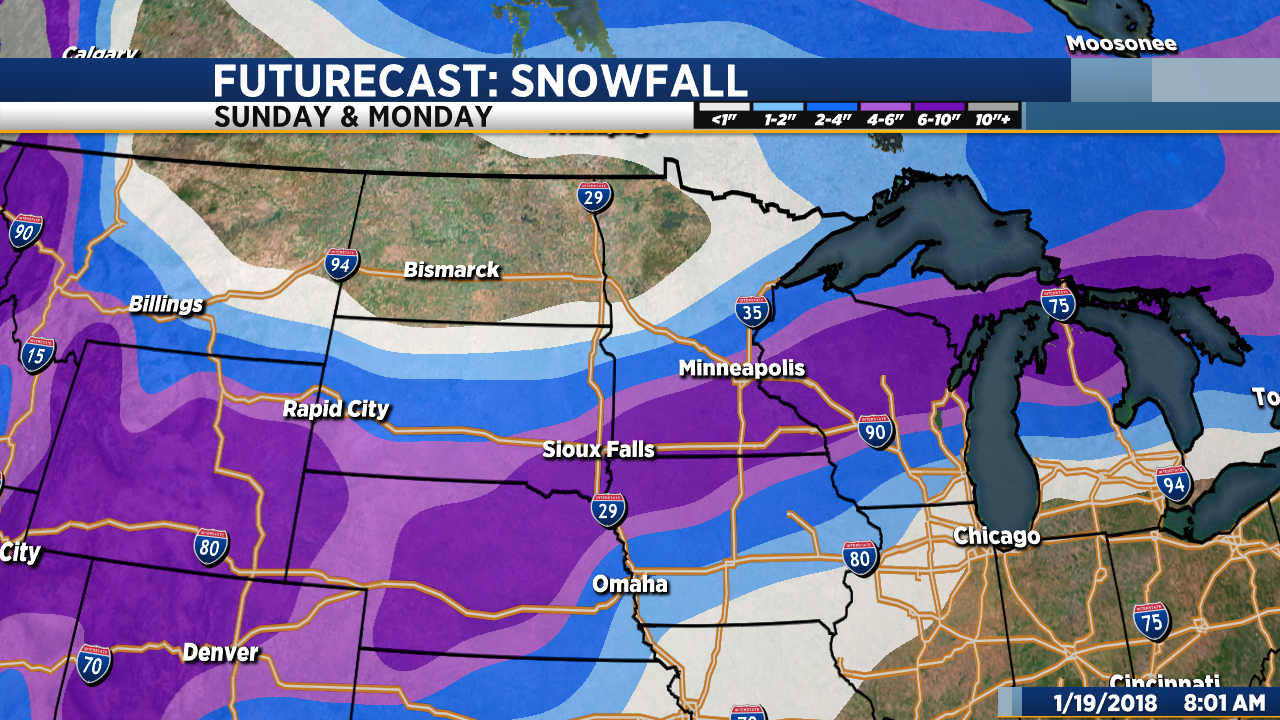
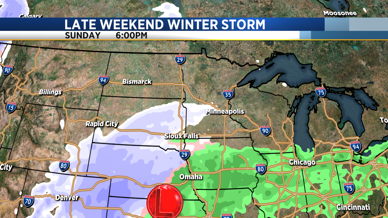
A significant winter storm system will impact our region late this weekend into early next week. As of now, it looks like the heaviest snow will fall across southeastern South Dakota, southwestern Minnesota and northwestern Iowa where 6 inches or more is possible. Snow will develop on Sunday with a brief period of rain – perhaps a little freeing rain or drizzle in some places – early in the afternoon as temperatures bump back up into the mid 30s for a short time. Snow will continue Sunday afternoon and Sunday night into Monday, becoming heavy at times. Strong northwest wind gusts will accompany the system and create areas of blowing snow late Sunday, Sunday night and well into the day Monday.
Keep in mind that the track and timing of this storm could change. Stay tuned… We will have updates as the system develops.
Snow Possible This Weekend
If you are getting a little tired of the cold, I have some fantastic news for you this morning. If you have the itch to do more skiing, snowmobiling, snow fort building or snow angel making, I have great news for you, too.
First let’s talk about the January thaw. Today will be sunny and quite a bit warmer than yesterday. High temps will climb into the 40s this afternoon. Tomorrow will be even warmer with afternoon temps in the upper 40s. Some places could get close to 50 degrees tomorrow. Mild weather will stick around through Saturday, and then we are in for some big changes during the last half of the weekend.
As I mentioned yesterday, we are keeping an eye on a potential winter storm system that could bring measurable snow and wind late this weekend into early next week. While much of our KSFY coverage area will likely get some snow, our latest data is suggesting that the system will have a more significant impact on the southeastern part of our KSFY coverage area… Southeastern South Dakota, southern Minnesota, western and northern Iowa and most of Nebraska. The system is still several days away, so it’s too early to pin down the track and get specific with potential snow totals, however, be aware that there is a good chance that a winter storm will impact the region on Sunday and Monday. Stay tuned for updates… We’ll get more specific with the storm track and snow forecast over the next couple of days.
In the meantime, enjoy the 40s!
Bitterly Cold with Blowing Snow
Get ready for another blast of bitterly cold, arctic air. Today will be partly to mostly cloudy and breezy with high temperatures below zero. The wind will be from the northwest gusting to between 20 and 30 mph and that will keep the wind chill factor in the 25 to 35 below zero range (even colder in some places) through tomorrow morning. Wind Chill Warnings and Advisories are in effect from today into tomorrow.
While I don’t expect much more than a few flurries today, the snow from yesterday will blow around, reducing visibility at times. The wind will decrease to about 10 to 20 mph tonight, 5 to 15 mph by tomorrow morning.
By tomorrow afternoon our temps will climb back above zero. That will be the start of a slow warm-up that will take us through the work week. By Friday, highs will be back in the low to mid 40s. The 40s are only going to hang around for about a day. The weekend will be colder with areas of snow possible late Saturday and Sunday.
Both ShawnCable.com and WXLab.com are the personal websites of Shawn Cable. Shawn is a freelance meteorologist based in Sioux Falls, South Dakota.