Give yourself plenty of time to get where you’re going this morning. The snow has ended in most places, but roads and sidewalks are snow-covered and slippery. Snowfall amounts range from between 3 and 5 inches with a few locations reporting a bit more and others reporting a bit less. The official total at Sioux Falls Regional Airport will end up being right around 3 inches.
Today will be mostly cloudy with another round of snow possible across central and southern South Dakota this afternoon. Amounts will range from about an inch or so in Pierre, Murdo, Gregory and Chamberlain to a couple of inches in Winner, Mission and White River. Some light snow is possible in Sioux Falls late this afternoon into this evening, but accumulation will be light across the metro area.
The rest of the weekend will be dry and cold. Highs will only reach the single digits to low teens today. By tomorrow morning, temperatures will drop to around 6 below zero in Sioux Falls to near 15 below zero across much of northern South Dakota. High temps will be stuck in the teens tomorrow, warming to the 20s by Sunday.
Some places could get a little light snow on Monday. Temps will warm a bit next week. Highs will stay in the teens to low 20s on Monday and Tuesday and then climb into the 30s by Wednesday.

Blog
More Snow on the Way
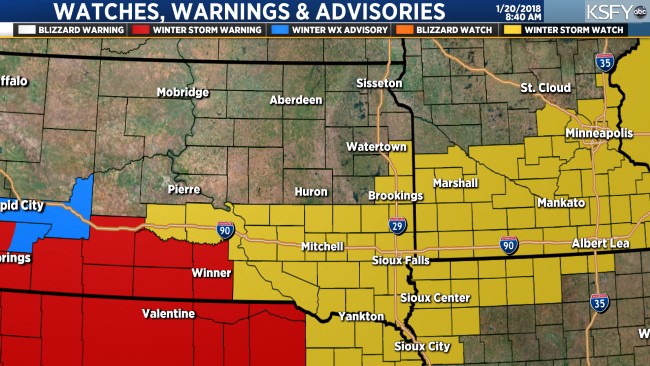
More snow is on the way. A Winter Weather Advisory is in effect for parts of northwestern, central and southeastern South Dakota, southern Minnesota, northern Iowa, and northeastern Nebraska from this afternoon through tonight.
Snow will develop from northwest to southeast through the morning. Snow will start to fall in Sioux Falls and across the tri-state area by late morning or early afternoon. snow will fall steadily through the afternoon with 1 to 2 inches of accumulation possible by 6 PM.
Snow will continue tonight with an additional 2 to 3 inches of accumulation for an overall total of about 3 to 5 inches. Snow will end by sunrise tomorrow.
Tomorrow in the weekend will be dry but cold. High temps will only reach the single digits to low teens on Friday and Saturday. Sunday will be mostly sunny and a bit warmer as highs were back into the mid 20s.
A Snowy Morning
You might want to get rollin’ a little early this morning because we’re going to have some snow for your drive to work and school.
A Winter Weather Advisory is in effect for Sioux Falls and parts of southeastern South Dakota, southwestern Minnesota and northwestern Iowa from 6 AM until noon today. About 2 to 3 inches of snow is possible in the Sioux Falls area with heavier amounts possible south and east of Sioux Falls. Parts of northwestern Iowa could get 4 to 6 or more inches of snow. Snow will end by early afternoon in Sioux Falls, gradually ending from west to east across Iowa and Minnesota throughout the afternoon.
The wind will be fairly light today, so blowing snow will not be a big issue. The exception will be central South Dakota, where gusts to between 20 and 30 mph will create areas of blowing snow at times this afternoon.
The rest of the week will be cold with on and off snow. Light snow is possible again tomorrow with another system that will have the potential to bring more measurable snow on Thursday into Friday. Stay tuned for updates! 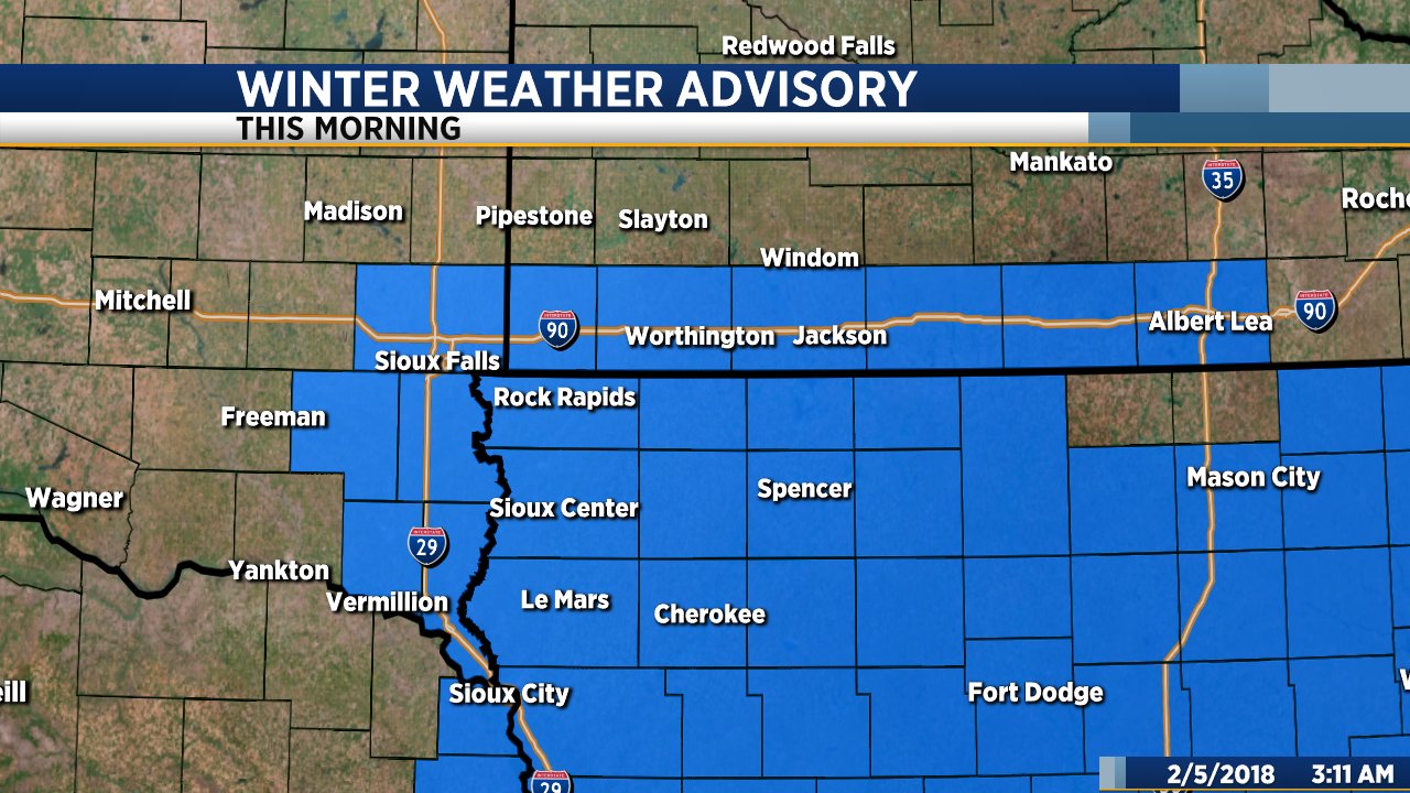
Warmer and Windy Today
Today will be partly to mostly cloudy, breezy and warmer. High temps will range from the upper 30s in Sioux Falls to the mid 40s along the James River to the mid 50s across central and western South Dakota. Wind will be a bit gusty from the south at about 20 to 30 mph.
Mild temperatures will stick around through tomorrow, then a cold front will bring highs back to the teens by Thursday. Temps will bump back to near 30 degrees on Friday, with light snow and colder temperatures in the forecast for the weekend.
Major winter storm this weekend
A Winter Storm Watch is still in effect from tomorrow afternoon through Monday. 6 to 10 inches of snow is possible with strong wind creating blizzard conditions at times.
Both ShawnCable.com and WXLab.com are the personal websites of Shawn Cable. Shawn is a freelance meteorologist based in Sioux Falls, South Dakota.