Get ready for another blast of bitterly cold, arctic air. Today will be partly to mostly cloudy and breezy with high temperatures below zero. The wind will be from the northwest gusting to between 20 and 30 mph and that will keep the wind chill factor in the 25 to 35 below zero range (even colder in some places) through tomorrow morning. Wind Chill Warnings and Advisories are in effect from today into tomorrow.
While I don’t expect much more than a few flurries today, the snow from yesterday will blow around, reducing visibility at times. The wind will decrease to about 10 to 20 mph tonight, 5 to 15 mph by tomorrow morning.
By tomorrow afternoon our temps will climb back above zero. That will be the start of a slow warm-up that will take us through the work week. By Friday, highs will be back in the low to mid 40s. The 40s are only going to hang around for about a day. The weekend will be colder with areas of snow possible late Saturday and Sunday.
Back Above Zero Today
It is another bitter, dangerously cold morning. Once again, a Wind Chill Advisory is in effect for most of the region through this morning. Actual temperatures are colder than 20 below zero with the wind chill factor dropping to 40 below or colder at times.
Despite the cold this morning, most places will climb back above zero this afternoon. That’s after over three straight days of below zero temperatures. If you’re keeping track, we dropped below zero at midnight on December 30th… So we’re looking at about 80 to 85 straight hours of below zero temperatures by the time we creep back above zero later today.
Unfortunately, our time above zero will be short-lived. A cold front will blast across the Dakotas later today into tonight, bringing a few scattered light snow showers later today into this evening and another below zero night tonight. While most nights this week will drop below zero, the good news is that all the high temperatures on the 7 Day forecast are above zero. By the weekend, morning lows will be back above zero with high temps in the 20s.
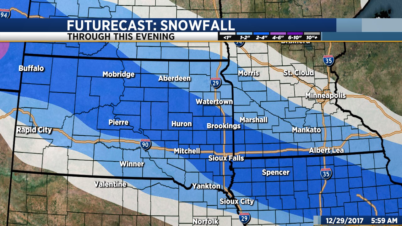
Snow Today… Deadly Dangerous Cold this Weekend
The weather is going to give us plenty of excitement as we head into the new year. 2 to 4 inches of snow today will be followed by frigid, dangerously cold temperatures this weekend. Most places will drop below zero this evening and won’t claw their way back above zero until sometime Tuesday afternoon.
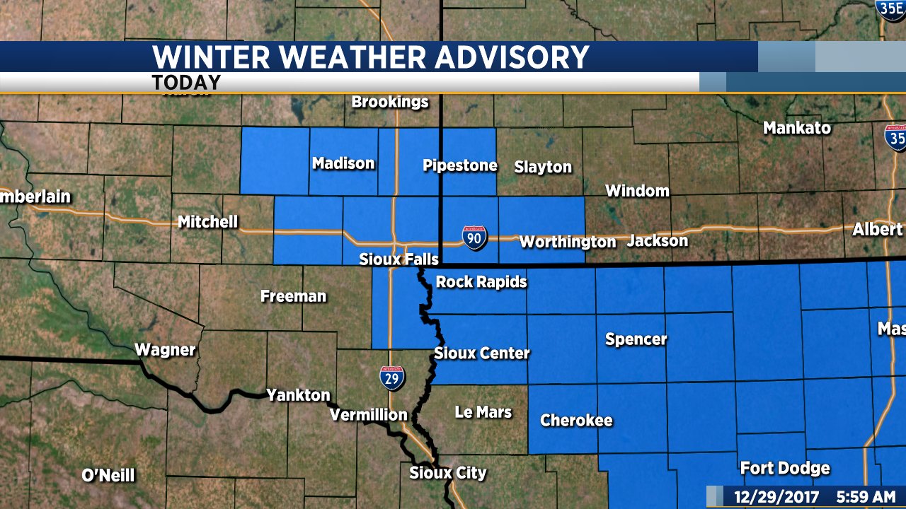
Snow will develop quickly this morning and continue into the afternoon. A Winter Weather Advisory is in effect through this afternoon for Sioux Falls and parts of southeastern South Dakota, southwestern Minnesota and northwestern Iowa. 2 to 4 inches of light, fluffy snow is possible. It won’t be terribly windy, but due to the fluffy nature of the snow even a 15 to 20 mph gust could create some visibility issues. Snow will end by late this afternoon.
After the snow, it is all about the cold. Temperatures will drop below zero this evening and stay below zero for almost four straight days. The coldest air will roll in just as we’re ringing in the new year. Sunday’s high will be close to 10 below with temperatures dropping to between 25 below and 30 below on New Year’s morning. That’s not wind chill factor, that’s the actual temperature. This is serious, deadly dangerous cold. Dress appropriately if you’re going out on New Year’s Eve.
Be safe, stay warm and have a happy New Year!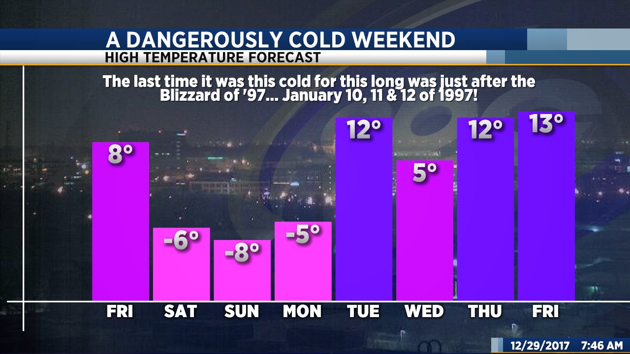
Both ShawnCable.com and WXLab.com are the personal websites of Shawn Cable. Shawn is a freelance meteorologist based in Sioux Falls, South Dakota.