
Winter Storm Update
The system has shifted slightly to the north again this morning, which means we’re looking at our heaviest snowfall totals along and north of US Highway 14. Blizzard Warnings remain in effect for a large portion of eastern and northeastern South Dakota into southwestern Minnesota, with Winter Storm Warnings in effect across much of central and southern Minnesota. A Winter Storm Watch remains in effect for locations farther south where there’s still a bit of uncertainty as to how far south the heavier snow bands will go. While the location of the heaviest snow band has shifted north, strong wind is going to be a significant factor with this system with blowing snow, reduced visibility and potentially blizzard conditions even in areas that don’t get the heavier snow.
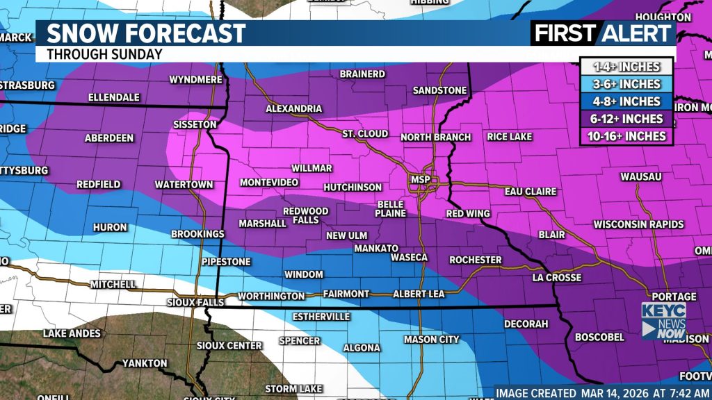
Here’s a quick breakdown of where things currently stand…
Sioux Falls Area
Timing: Snow develops later this evening, becoming heavier overnight through Sunday morning.
Amounts: Sioux Falls remains in the transition zone on the southern edge of the storm, with around 1–3 inches likely. Higher totals are expected north toward Highway 14 and southwest Minnesota.
Impacts: Wind gusts up to 55–60 mph Sunday could produce blowing snow and near-blizzard conditions, even with lighter snowfall.
Central & Southern Minnesota
Timing: Snow develops late this afternoon into this evening, becoming heavy overnight into Sunday morning.
Amounts:
Mankato / Highway 14 corridor: 6–10+ inches, with localized amounts over 12 inches possible.
Twin Cities metro: 10–16 inches likely, with locally higher totals possible depending on where the heaviest band sets up.
Impacts: Heavy snow and increasing wind Sunday could make travel dangerous to impossible.
Along & South of I-90
Timing: Saturday evening into overnight.
Amounts: Some rain or a wintry mix early could limit snow totals compared to areas farther north before changing to snow overnight.
Impacts: Potential for brief icing followed by blowing snow as wind increases Sunday.
Northeastern South Dakota
Timing: Snow increases later today with the heaviest snow tonight through Sunday morning.
Amounts: 12–18 inches possible, especially along the Prairie Coteau and toward the Minnesota border.
Impacts: Wind gusts 40–50+ mph with whiteout / blizzard conditions likely.
Bottom line: The worst conditions still look to occur this evening through Sunday, when heavy snow and strong wind could make travel very dangerous or impossible in some areas.
Posted 3/14/2026 at 7:45 a.m.
