Winter Storm will Impact Region on Friday

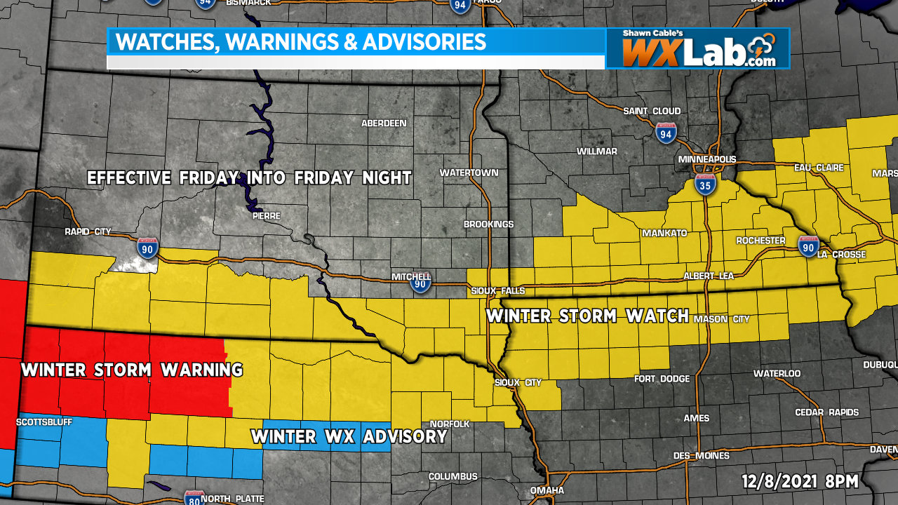
We are tracking a winter storm system that could bring significant snow to parts of our region Friday, Friday night into Saturday. A Winter Storm Watch has been issued by the National Weather Service for much of Southern, South Dakota, Northern Nebraska, southern Minnesota and northern Iowa Friday afternoon into Saturday morning. 4 to 8 inches of snow is possible in the Watch area

This system is still a couple days away. As it develops and we get a better idea as to where this storm will track, we will likely make changes and adjustments to our snow forecast. Stay tuned for updates.

A Bonus “Nice Day” Tuesday

If the snow, wind and cold the past few days has brought on feelings of guilt and regret… You know, all of those outdoor things that you had intended to do… Clean the garage. Rake the leaves. Take down the trampoline. I could go on and on.

You can feel a little better because we’re going to get a bonus day this week. Tuesday. Highs will climb into the 50s and 60s with a few places reaching 70 degrees. It will be a bit breezy, bit it will be warm.

Don’t waste it because it’s only gonna last a day. Highs will drop back into the 30s and 40s by Wednesday and stay there for a while.

First Winter Storm of the Season

There is a lot going on across the Northern Plains today. High Wind Warnings are in effect across the Dakotas and Nebraska today into tonight. A Blizzard Warning is in effect for northeastern South Dakota this evening through Friday. A Winter Weather Advisory is in effect for parts of eastern and southeastern South Dakota, western and southern Minnesota, and northern/northwestern Iowa from later today and tonight through Friday.

The wind has already gusting to 60 between 60 and 70 mph along and west of the Missouri River today. Wind gusts will increase from west to east throughout the day today and into tonight. Snow will develop late today into this evening across the eastern Dakotas and move into Western Minnesota and Iowa by mid to late evening. The snow will not be terribly heavy. Around an inch or two is possible with heavier amounts in the 3-5 inch range across northeastern South Dakota and western Minnesota, but with wind gusts to between 50 and 60 mph, it won’t take much to create blowing snow and blizzard conditions that could reduce visibility to near zero at times.

Travel conditions would likely be fairly rough this evening through much of Friday. Conditions will gradually improve from west to east during the day Friday.

If you can avoid travel, that would be great. If you must travel, make sure you have a full gas tank and plenty of warm clothes and blankets in the trunk just in case.